Latitude and Longitude meaning
November 9, 2020 by Tomas
If you are looking to understand more about Latitude and Longitude coordinates system, keep reading.
What is Latitude and Longitude in simple terms?
Latitude and Longitude defines a Earth's grid system (like a cartesian system) so that we can define / locate any single point on earth with two simple digit numbers (Latitude and Longitude).
For example, to locate where is London, we can just say 51.5073219 for
Latitude, and -0.1276474 for Longitude.
Latitude refeers to the horizontal axis (also called Lines of Latitude), and Longitude to the Vertical axis (also called Lines of Longitude).
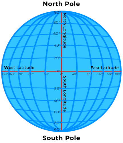
Latitude
Lines of Latitude (also known as parallels) are (imaginary) horizontal lines around the Earth, parallel to the Equator. Lines run East-West all the way around the Earth.
There are infinite (horizontal / Latitude) lines as how as accurate you want to be.
Lines of Latitude is the X axis in a catersian system, measured in degrees (°) and the values range from
+90° to -90°.
Going from North to South:
- The North Pole corresponds to
+90°(or 90° North) - The Equator corresponds to
0° - The South Pole corresponds to
-90°(or 90° South)
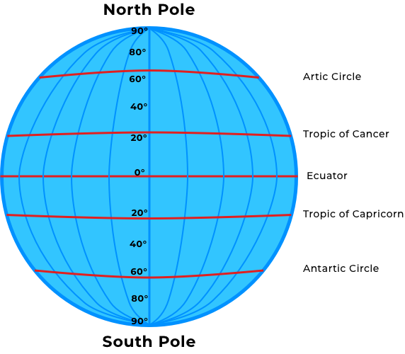
The Five Major Latitude Lines
The five major Latitude lines from North to South can be described as Artic Circle, Tropic of Cancer, Equator, Tropic of Capricorn and Antartic Circle:
- Artic Circle (
66.5°) - Tropic of Cancer (
23.5°) - Equator (
0°) - Tropic of Capricorn (
-23.5°) - Antartic Circle (
-66.5°)
Longitude
Lines of Longitude (also known as meridians) are (imaginary) vertical lines around the Earth, parallel to the Prime Meridian. Lines run North-South / Pole to Pole.
There are infinite (vertical / Longitude) lines as how as accurate you want to be.
Lines of Latitude is the Y axis in a catersian system, measured in degrees (°) and the values range from
+180° to -180°.
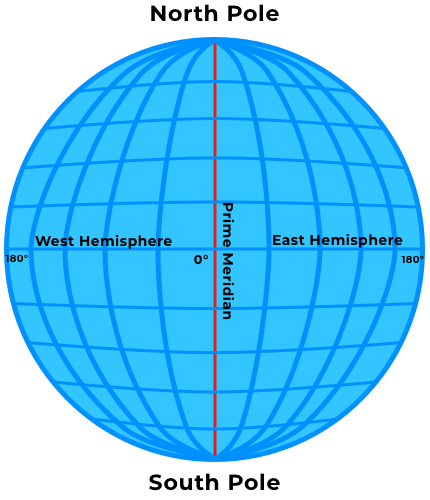
The Prime Meridian divides the Earth into two Hemispheres: West and East
- The Western Hemisphere corresponds between
+180°(or 180° West) and0° - The Prime Meridian corresponds to
0° - The Eastern Hemisphere corresponds between
0°and-180°(or 180° West)
The Two Major Longitude Lines
The two major Longitude lines can be described as:
- Prime Meridian (
0°) - The Anti-meridian (
-180°) which is also (+180°)
Lines of Latitude and Longitude
Lines of latitude and longitude are part of the grid system that helps us navigate and describe a specific point on Earth.
Lines of latitude run in an East-West (horizontal) direction across Earth while Lines of longitude run in a North-South (vertical) direction. Although these are only imaginary lines, with the sole purpose of creating a global (imaginary) grid to locate and find any particular place on Earth, with two simple numeric values (Latitude and Longitude).